At the beginning of 2022, IGN FI won a contract with the Senegalese Air Force for visual flight mapping of the territory. For several decades, pilots in Senegal had to fly using aeronautical maps dating from the 1970s.
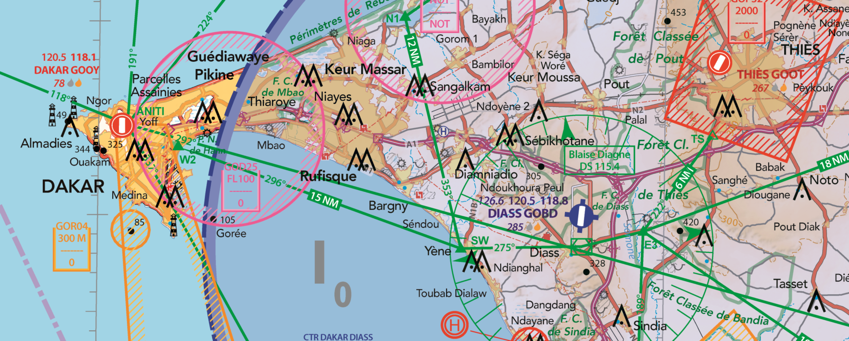
Cartographer Alain Rivas and project manager Auriane Sacoman, founder of the “Air Million” series of aeronautical charts, worked together in 2022 to produce an up-to-date visual flight map of Senegal. At a scale of 1:500,000, the map is divided into two sheets, one for the east and one for the west, covering the airspace of Senegal, the Gambia, and parts of the airspace of Mauritania, Mali, Guinea Bissau and Guinea.
What is the purpose of an aeronautical chart?
While large airliners and supersonic aircraft can fly by instrument, at high altitude, day and night, and in all weathers, small aircraft can only fly when it is daylight, the weather conditions are favourable for visibility, and the altitude allows them to save oxygen. The former are said to follow Instrument Flight Rules (IFR), while the latter follow Visual Flight Rules (VFR) on the principle of “see, be seen and avoid”. Therefore, aircraft flying by visual flight rules need to find their way around, set a course and follow a heading, while checking that they are following the ‘air traffic regulations’.
The challenge of the aeronautical chart is to provide both topographic information (relief, urban areas, roads, railways, waterways, etc.) and aeronautical information (aerodromes, air corridors, obstacles, restricted areas, radio navigation aids, etc.). In other words, the aeronautical chart stacks two layers of information, a topographic background and an aeronautical overlay. This aeronautical overlay is the flat representation of a three-dimensional space, with air corridors defined laterally by geographical coordinate points and vertically by a lower and an upper limit.
Six months after the start of the project, the VFR map of Senegal was released in v0.
The second phase of the project: training and equipment
A second phase of the project then began, which consisted of training a cartographic unit within the Air Force. In total, more than ten months of training and twelve modules are to be provided: introduction to aeronautics, GIS and cartography; remote sensing; geodesy and topometry; field collection; photogrammetry; database management, etc. The objective is to train army personnel in modern mapping techniques while giving them the skills to update their VFR map or to create new ones entirely adapted and personalised to their requirements.
To this end, an entire room at the Ouakam air base in Dakar has been fitted out and equipped with computer stations, small and large format printing equipment, a server and appropriate software.
Seven military personnel and one civilian will benefit from this very intensive and high-level training. “We are very pleased with the excellent collaboration that is taking place with the Air Force General Staff, with the support of the project partners, AIBD SA (Aéroport Blaigne Diagne SA) and FATCO (Foreign Asset Trade Company),” says Christophe Grateau, regional director at IGN FI.